

Collection: Osher Map Library Collection
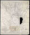
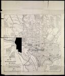
Name: Map of the District of Columbia and Vicinity showing the principal points of interest including the present condition of the Defenses of Washington. Map of Washington, D.C., and suburbs showing the latest streets and all the new railway and street-car routes drawn & published by the Engineering Platoon of the Engineer Corps, D.C.N.G., F.L. Averill, C.E., First Lieut. Comdg. Platoon.
Barcode:
Image Number:
Creator:
Publishing Location:
Notes: Note: "Copyright 1892, by F.L. Averill." Accompanied by text: Guide to and Maps of the National Capital and Vicinity including the Fortifications." 31 pages, illustrated Suburbs map includes index to points of interest.
Date/Date Range Produced:
Date/Date Range Published:
Language:
Dimensions: 60 x 51 cm. and 51 x 51 cm sheet 66 x 55 cm
Physical Description: 2 maps on 1 sheet: both sides
LC Call Number: G3851.R4 1892 .A91
OCLC: 17328027
Accession Number: OML-1892-36
Permanent URL: